Tuesday, March 1, 2011
LADAR map
link LADAR stands for Laser Detection and Ranging. These maps are created by sending laser beams at objects and lighting them up. This can tell you the distance to the object or other information about the object.
Doppler Radar Map
link Doppler radars work by sending out beams and then recording how much of the beam returns back. If the beam returns back then it means that it was reflected by rain or snow or some kind of precipitation. These maps are used a lot by weather stations to predict where a storm is going.
Black and White Aerial Photo Map
link Black and white aerial photo maps are simply an aerial view of a certain area that is in black and white. This is an aerial black and white photo of Bloomsburg.
Infrared Aerial Photo
Infrared aerial photo maps use infrared technology to distinguish between different things like ecosystems and rivers. The infrared distinguishes thing by picking up the different temperatures of different things.
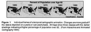
Cartographic Animation
link Cartographic animations display change in some aspect over time. They do this by having multiple maps that depict the changing information over time. This map shows the percentage of the population that is over the age 65.
Subscribe to:
Comments (Atom)


